do geography / zwischenraumkarten
10 maps about the interspace
route frequency map
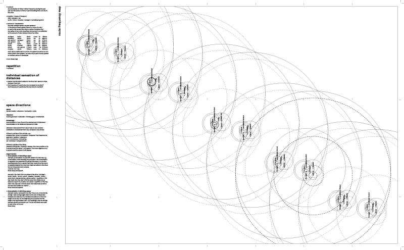
// method: documentation of cities i visited frequently during the past year and the amount of time i spent travelling from one city to the other
// location / means of transport // train / airplane / car // berlin / zŁrich / dresden / stuttgart / schwšbisch gmŁnd
// structure / visualization: the map contains several circular systems / in the centre of each system there is a name of a city / on each orbit around that city is a name of another city / the radius of one circle visualizes the journey time multiplied by the amount of trips between those two cities
stuttgart / berlin / 55min / plane / 3x / 165min
konstanz / zŁrich / 70min / car / 4x / 280min
sch. gmŁnd / stuttgart / 45min / car / 6x / 270min
sch. gmŁnd / ulm / 60min / car / 5x / 300min
zŁrich / berlin / 75min / plane / 8x / 600min
berlin / dresden / 125min / train / 5x / 625min
zŁrich / sch. gmŁnd / 210min / train / 13x / 2730min
dresden / zŁrich / 720min / train / 7x / 5040min
each city is positioned in a centre of a system as well as on one orbit of each other system / as every city is part of every system an endless pattern is developed
//non-linear map
content:
repetition // boredom
individual sensation of distances // places most far apart related to the time that i spend on trips between those two // the frequency of a particular trip increases its duration? // the frequency of a particular trip shortens its duration?
<< >>
<< back to overview
<< back